NOAA Predicts a Warmer Summer, Cooler Waters in Northeast
- Melissa Waterman

- Jun 27, 2025
- 3 min read
By Melissa Waterman, adapted from The Maine Monitor
Warm Summer
The National Oceanographic and Atmospheric Administration’s (NOAA) forecast for July, August and September could be called …. steamy.
In New England temperatures will be above average for the three-month period. In addition, it’s due to be more humid. The added humidity will make above-average temperatures even more stressful on the body.

Extreme heat can be particularly dangerous to Mainers since most residents are not accustomed to the high temperatures experienced most summers in other parts of the country. In addition, Maine residents do not use air conditioning as much as the rest of the country. Just 10% have central air conditioning at home compared to 67% nationally.
In Maine the National Weather Service will issue a “heat advisory” when the heat index, a combination of temperature and relative humidity, tops 95. A heat warning is issued when that index reaches 105. The standards for heat advisories and warnings vary by region, because heat poses different threats in different areas of the country.
Heat can have a physiological effect when temperatures reach the 80s, and heat-related health impacts increase as temperatures go up from there. Research by the Maine Center for Disease Control indicates that locally, deaths and emergency department visits increased significantly on days when the heat index was 950 F. compared with 750 F.
Heat extremes are expected to become more common in Maine as the climate warms, said Sean Birkel, Maine’s state climatologist and a research assistant professor at the University of Maine. Since the 1950s, average summer temperatures have risen by about 30 F. in Portland, Bangor, and Caribou.
Cooler Ocean
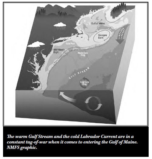
In contrast, deep waters in the Gulf of Maine are expected to remain cooler than in recent years. This prediction is from the first experimental seasonal ocean outlook released by NOAA scientists in April. It is a shift from previous patterns. From 2004 to 2013, sea surface temperatures in the Gulf of Maine warmed faster than anywhere else in the world.
Conditions at the bottom of the ocean along much of the Northeast U.S. coast have been colder than normal in the first few months of 2025. Data collected in March 2025 by several surveys showed bottom temperatures across much of the Gulf of Maine that were 0.5–2.00 C. (0.9–3.6 0 F.) below normal for March, though a few locations reported slightly warmer than normal conditions. The data also showed cooler than normal conditions all along the edge of Georges Bank, deep along the Mid-Atlantic Bight shelf break and slope, and patches of near-to-slightly-above normal temperatures inshore around Long Island.
NOAA’s Geophysical Fluid Dynamics Laboratory conducted experimental model predictions of the next 10 years which suggest that the warming will pause over the next decade, with the temperature trend at the surface remaining flat or slightly cooling. In the model, this pause in the warming trend is associated with slow variability in the ocean and atmosphere that takes place over several years. This will ultimately result in a temporary southward displacement of the warm Gulf Stream current, which allows colder water into the Northeast U.S. region.
The cool water observed this winter and spring, its predicted continuation at depth this summer, and several cool pulses observed in 2024 point to this prediction being accurate so far. However, several additional years of data will be needed to confirm whether the warming trend has paused as predicted.


Comments