Your Questions, Answered: Data from the Gulf of Maine
- Melissa Waterman

- Apr 3
- 2 min read
How do we know what is happening in the depths of the Gulf of Maine?
One way is through a sophisticated network of deep-water buoys managed by
the Northeastern Regional Association of Coastal Ocean Observing Systems
(NERACOOS). Seven deep water oceanographic buoys in the Gulf that provide
near real-time data on ocean conditions.

Established in 2009, NERACOOS is a non-profit organization that serves as part
of the U.S. Integrated Ocean Observing System (IOOS). Its primary mission is to
provide high-quality, real-time data on ocean waters from Long Island Sound
to the Canadian Maritimes.
Rather than just a collection of buoys, NERACOOS acts as a bridge between the scientific community and the public. By partnering with universities such as the University of Maine, NERACOOS transforms raw oceanic data into usable information for fishermen, search-and-rescue teams, weather forecasters, and climate researchers.
The stars of NERACOOS are the deep-water oceanographic buoys. Th ese are massive research platforms weighing more than a ton and rising up to eight feet above the waterline.
Sensors along their anchor chains, which can extend over 250 meters deep, provide additional readings on salinity, pH, and more. Each buoy is equipped with a suite of sensors. Th ese sensors measure:
Atmospheric Conditions: Wind speed, direction, gust strength, air temperature, and barometric pressure.
Surface Conditions: Wave height, period (the time between waves), and direction.
Subsurface Oceanography: Water temperature, salinity (saltiness), and current
velocity.
Biological and Chemical elements: Chlorophyll-A levels (indicating plankton
growth), dissolved oxygen, pH (to track ocean acidification), and nutrient
concentrations like nitrate and silicate.
Data is recorded every six minutes to an hour and stored on an internal computer
before being beamed via satellite or cellular technology to land-based
receivers, such as the University of Maine. The university sends the raw data
to the Gulf of Maine Research Institute’s Ocean Data Product team, who transform it into usable information.
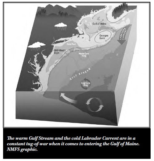
The buoys are placed to monitor specific “chokepoints” and biological hotspots within the Gulf. Buoy M sits in the Jordan Basin. Th is deep basin acts as a reservoir for the Gulf ’s interior waters, and monitoring it allows scientists to track how the North Atlantic Oscillation—a major weather pattern—influences regional water properties. Other buoys, like Buoy E and Buoy I, monitor the Eastern and Western Maine Coastal Currents.
The buoys’ data serves two primary purposes. First, it provides real-time information on ocean conditions, which is crucial for people making decisions about whether or not it’s safe to go to sea, such as fishermen or ferry captains. Second, the long-term collection of the data helps researchers understand trends and patterns in the Gulf of Maine, offering insights into environmental changes over time and how those changes might be affecting marine ecosystems.
These buoys provide the crucial information that feeds practical applications such as meteorological forecasts, ocean simulation models, and near real-time
products like the Mariner’s Dashboard — a NERACOOS tool designed to help
anyone who goes out on the ocean understand current ocean conditions.
To learn more and to view NERACOOS data, visit:

Comments